The first nation people who cared for the land of the Cape Paterson area were from the Yowenjerre clan of the Bunurong people, the traditional owners of the land in the region.
Prior to human habitat, the coastal area would have been a completely different landscape to what it is today. In fact, the coastal geology represents the accumulation of sediments formed in a vast rift valley that existed between the south coast of Australia and Antarctica when still attached before they parted in the breakup of the supercontinent Gondwana – a wide, flat valley that was rich in plant and animal life. These Early Cretaceous sedimentary rock outcrops found today along the Bunurong Coast are dated at 115-200 million years old and contain Australia’s first dinosaur fossils which were first discovered in 1903 and the oldest fossil evidence of birds in Australia.
The Cape commissioned an ecological study by Damien Cook, the Ecological Restoration Strategy for The Cape Paterson Ecovillage Site in February 2012. I have used this study as the basis for information around the landform, ecology and flora descriptions of The Cape.
A full copy of this paper is available here for further reading.
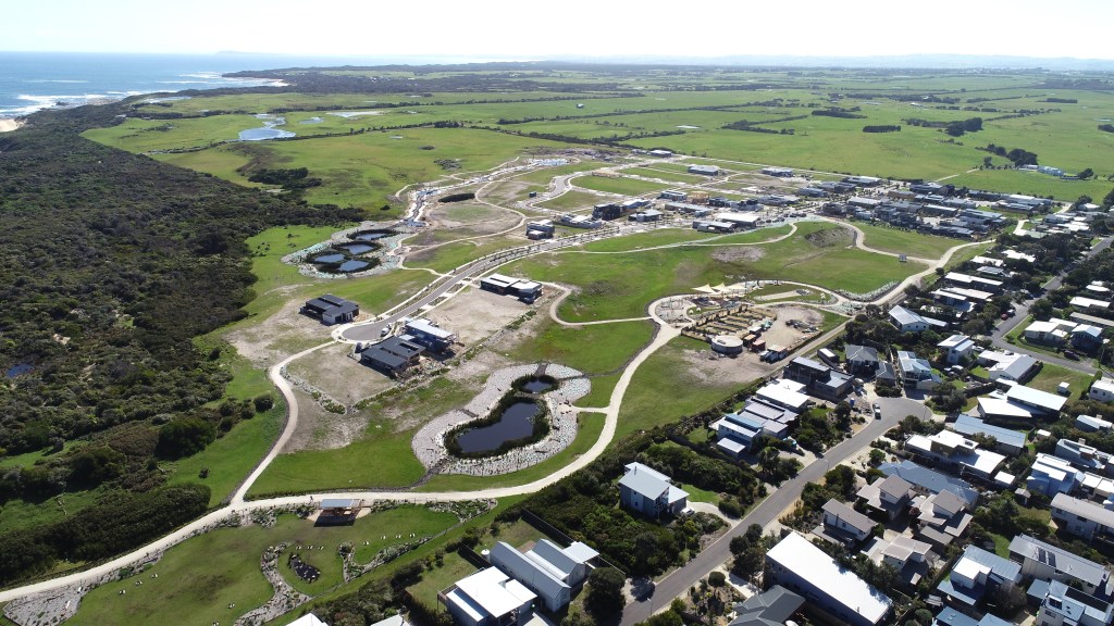
Today, the topography of the area is an undulating dune landform ranging up to 30 metres in elevation. It is reflective of different sea levels in the past and the influence of wind which has subsequently shaped a previously active dune landscape. The Cape site design aims to conserve these geomorphically significant landscape features such as remnant, stabilised dunes and ancient coastlines.
Prior to European settlement, The Cape site hosted a range of different native plant communities: heathland, coast woodland, along with swamp and brackish scrub. The vegetation has been profoundly altered from that time by vegetation clearing, grazing, soil disturbance, hydrological changes and weed invasion. Today, apart from small pockets of remnant vegetation along bordering roads, a small natural wetland in the south east corner, and some swamp scrub, The Cape vegetation is primarily pasture of introduced grasses and weeds. The Bunurong Coastal Reserve has more intact native vegetation including coastal dune scrub, coastal banksia woodland, sand heathland, wet heathland and swamp scrub. The Ecological Restoration Strategy by Damien Cook, identified 155 plant species within The Cape and coastal reserve area of which 78% were indigenous and 22% exotic.

Despite the altered landscape, the same ecological strategy identified the The Cape in conjunction with the Bunurong Coastal Reserve as still being able to provide valuable habitat for native mammals, birds, amphibians and reptiles. It is home to kangaroo, wallaby, wombat, echidna, antechinus, and 100 bird species identified to date, including Latham’s Snipe, Hooded Plover, Royal Spoonbill and Peregrine Falcon. With habitat restoration and expansion, The Cape has the potential to attract more rare and vulnerable species with the improvement of different habitat areas with indigenous vegetation.
One of the principal goals of The Cape is to continually improve the habitat and provide an environment that regenerates indigenous flora and attracts native wildlife. It is an environmental net gain project – the site will feature more restored vegetation after the project is complete than existed before, creating habitat for the special plants and animals that call the site home. Key features of the re-established habitat include corridors and stepping stones of vegetation, vegetated street swales, extensive wetlands, marshes, and a reconstructed creek-line with ponds and associated habitat infrastructure such as stags, logs and rocks. To date, more than 100,000 local indigenous plants have been planted from collected and propagated seed. As part of its environmental and wildlife conservation commitment, The Cape is a registered Land for Wildlife property.
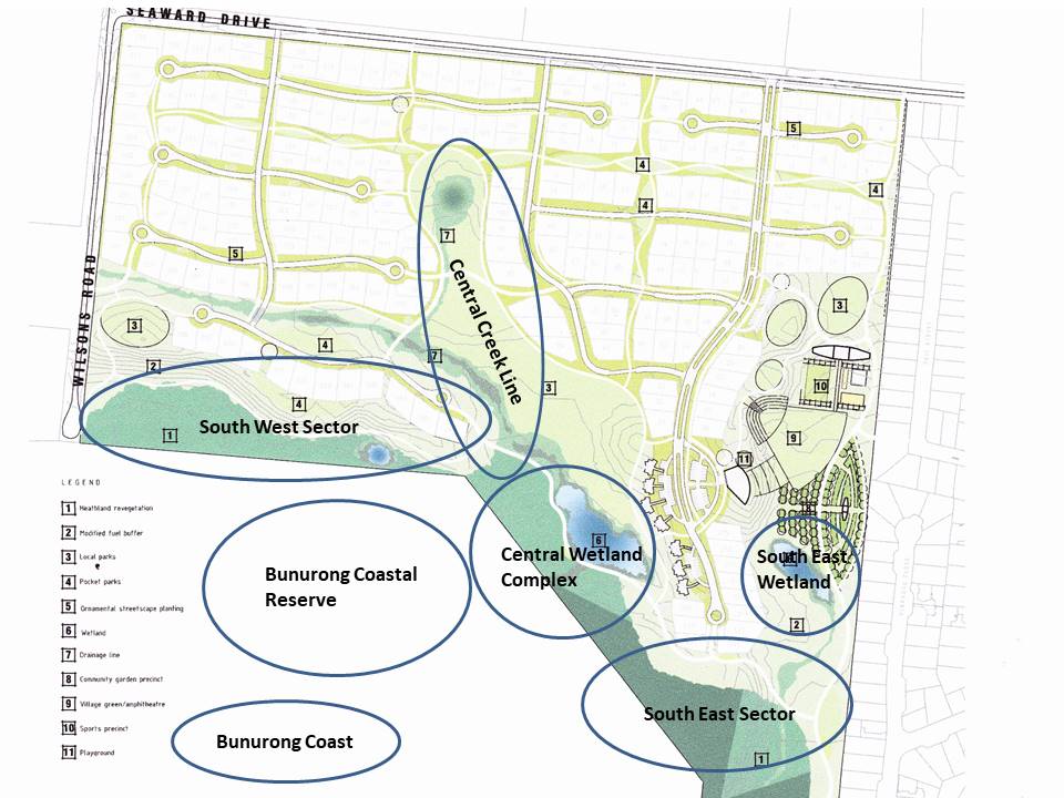
Use the drop down menu under the Ecology and Landform menu tab above to learn more about the key landform elements that feature within The Cape and along the Bunurong coastline, based on the map below.